The Township of Huron-Kinloss is committed to protecting, and improving, water quality in local rivers and Lake Huron. The Township implemented a mandatory septic inspection program in 2007 in order to address one of the possible sources of water contamination, faulty or malfunctioning private sewage systems. The initial goal was to have each of the approximately 3000 systems inspected within eight years.
BMROSS was contracted to carry out the program delivery, including phasing the contacts with landowners, inspection, reports to owners, and program reporting to the Township. Information management is a vital aspect of this project due to the large number of properties, multiyear implementation, and at this point, multi-phased since 2015 marked the second round of inspections for each property.
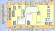
An entire information management system was developed from scratch for this program that satisfies the needs of field data collection standards and efficiency, reporting both in mapped and report form for each individual property, and the organization of related information such as permits, photos, property owner contact history and repair records. It involves both GIS and database interfaces to meet multi-user needs.
A data model has been developed to allow for interdependencies of information and for standardized reporting. The core of the data model is an ESRI ArcGIS geodatabase, containing all of the spatial features such as septic tank, leaching bed, water wells, homes, parcels and pipes. The features of a geodatabase have allowed the accurate and fast collection of field data with a GPS using ESRI’s ArcPad through the use of default values and domains. The ArcPad tool in ArcGIS Desktop has allowed the efficient updates to the main database by the inspector.
Within the GIS, a routine has been written in VBA that allows office staff to cycle through the new inspections and automatically generate a hard copy map for the property owner, as well as a soft copy PDF that is linked to the appropriate property.
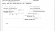
A frontend in a relational database, MS Access, was created in order to allow for development of appealing client reports, as well as a method for non-GIS users to have access to, and limited editing abilities, for the geodatabase. The printing of reports is automated, as well as the creation of a supplemental form that is sent with any reports where repairs are recommended. The form is sent back to BMROSS for e-filing against the property.
The database also allows for the management of non-spatial data for each property, including scans of the septic permit, photographs, the system map and all contacts with the property owners. The relationships between each of these features is either the property assessment number or a unique inspection ID. A new feature for the database is an allowance for multiple inspections and related data per property.